
About Malappuram
Malappuram is a culturally rich and naturally beautiful district in northern Kerala, known for its historic heritage, vibrant traditions, scenic landscapes, rivers, forests, and diverse tourist attractions. The district was formed on 16 June 1969 and has developed into an important centre for education, trade, culture, and tourism, The district is surrounded by the Arabian Sea, Nilgiri Hills, Kozhikode, Wayanad, Palakkad, and Thrissur, offering a unique combination of coastal, hilly, and forest landscapes. Malappuram is also home to important rivers such as the Chaliyar, Kadalundippuzha, Bharathapuzha, and Tirurpuzha, With its historical landmarks, temples, mosques, cultural festivals, traditional art forms, beautiful beaches, waterfalls, and hill destinations, Malappuram offers a memorable experience for residents and visitors. The district continues to grow while preserving its rich cultural heritage and natural beauty.
Total Towns & Administrative Information
Malappuram District has a well-organized administrative system that supports effective governance and public services across the district. The district consists of 7 taluks, 138 villages, 15 blocks, 94 Grama Panchayats, 12 municipalities, and 2 revenue divisions, The seven taluks of Malappuram are Eranad, Nilambur, Perinthalmanna, Tirur, Tirurangadi, Ponnani, and Kondotty. The district also has 16 Assembly Constituencies and 2 Parliament Constituencies, representing the diverse communities and regions of Malappuram.
7 Taluks
Eranad, Nilambur, Perinthalmanna, Tirur, Tirurangadi, Ponnani, and Kondotty.
138 Villages
The district’s villages form the foundation of its rural administration and local communities.
15 Blocks
Block-level administration supports development and public services across different parts of the district.
94 Grama Panchayats
Local self-government institutions responsible for delivering essential services and supporting rural development.
12 Municipalities
Urban local bodies managing civic services and development in the district’s towns.
2 Revenue Divisions
Revenue administration is organized through two revenue divisions for efficient governance.
16 Assembly Constituencies
The district is represented through 16 Assembly Constituencies in the Kerala Legislative Assembly.
2 Parliament Constituencies
Malappuram District is represented through two Parliament Constituencies.
Population Details
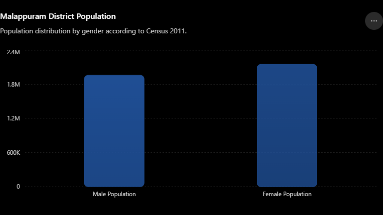
According to the 2011 Census, Malappuram District has a total population of 4,112,920, making it one of the most populous districts in Kerala. The district has 1,960,328 males and 2,152,592 females, with women forming a slightly larger share of the population, Malappuram has a sex ratio of 1,096 females per 1,000 males, reflecting the higher number of females compared with males. With a population density of 1,159 people per square kilometre, the district has a large and diverse population spread across its urban and rural regions.
Population Information
- Total Population: 4,112,920
- Male Population: 1,960,328
- Female Population: 2,152,592
- Sex Ratio: 1,096 females / 1,000 males
- Population Density: 1,159 people / sq. km
Population Chart
For the Malappuram District website, a bar chart comparing male and female population will be clear and visually appealing:
Measurements & Geographical Data
Measurements & Geographical Data
- Total Area: 3,550 sq. km
- Formation Date: 16 June 1969
- Eastern Boundary: Nilgiri Hills
- Western Boundary: Arabian Sea
- Northern Boundary: Kozhikode and Wayanad districts
- Southern Boundary: Palakkad and Thrissur districts
Geographical Regions
Malappuram district can broadly be divided into three geographical regions:
- Lowland – Coastal areas along the Arabian Sea, characterized by beaches, backwaters, and fertile agricultural land.
- Midland – Central areas with rolling hills, valleys, rivers, and extensive agricultural fields.
- Highland – Eastern areas dominated by hills and forest landscapes, forming part of the Western Ghats.
District Statistics – Malappuram
Malappuram is one of the prominent districts of Kerala, known for its diverse geography, large population, and extensive local administrative network. The district covers 3,550 sq. km and had a population of 4,112,920 according to the 2011 Census. It is administratively organized into 7 taluks, 15 blocks, 138 villages, 94 panchayats and 12 municipalities. The district has a unique combination of urban and rural settlements, with several major towns serving as important centers for trade, education, healthcare, transportation, and public services. The district’s population is distributed across a wide range of coastal, midland, and highland areas, contributing to its social and geographical diversity. Malappuram has also made significant progress in education and literacy, supported by a strong network of schools, colleges, professional institutions, and skill-development centers. With a literacy rate of over 93%, education plays an important role in the district’s social and economic development.
Previous History of Malappuram
Malappuram has a long and eventful history. The region was historically important because of its connection with the Zamorins of Kozhikode and its strategic location in the Malabar region.
The district is also closely associated with the Khilafat Movement and the Mappila Revolts, which played an important role during the period of British rule in India.
Malappuram has been home to many renowned poets, writers, political leaders, and religious personalities. Its mosques, temples, festivals, traditions, and cultural practices have contributed significantly to Kerala’s rich heritage.
The modern Malappuram District was officially formed on 16 June 1969, bringing together areas to support better administration and regional development